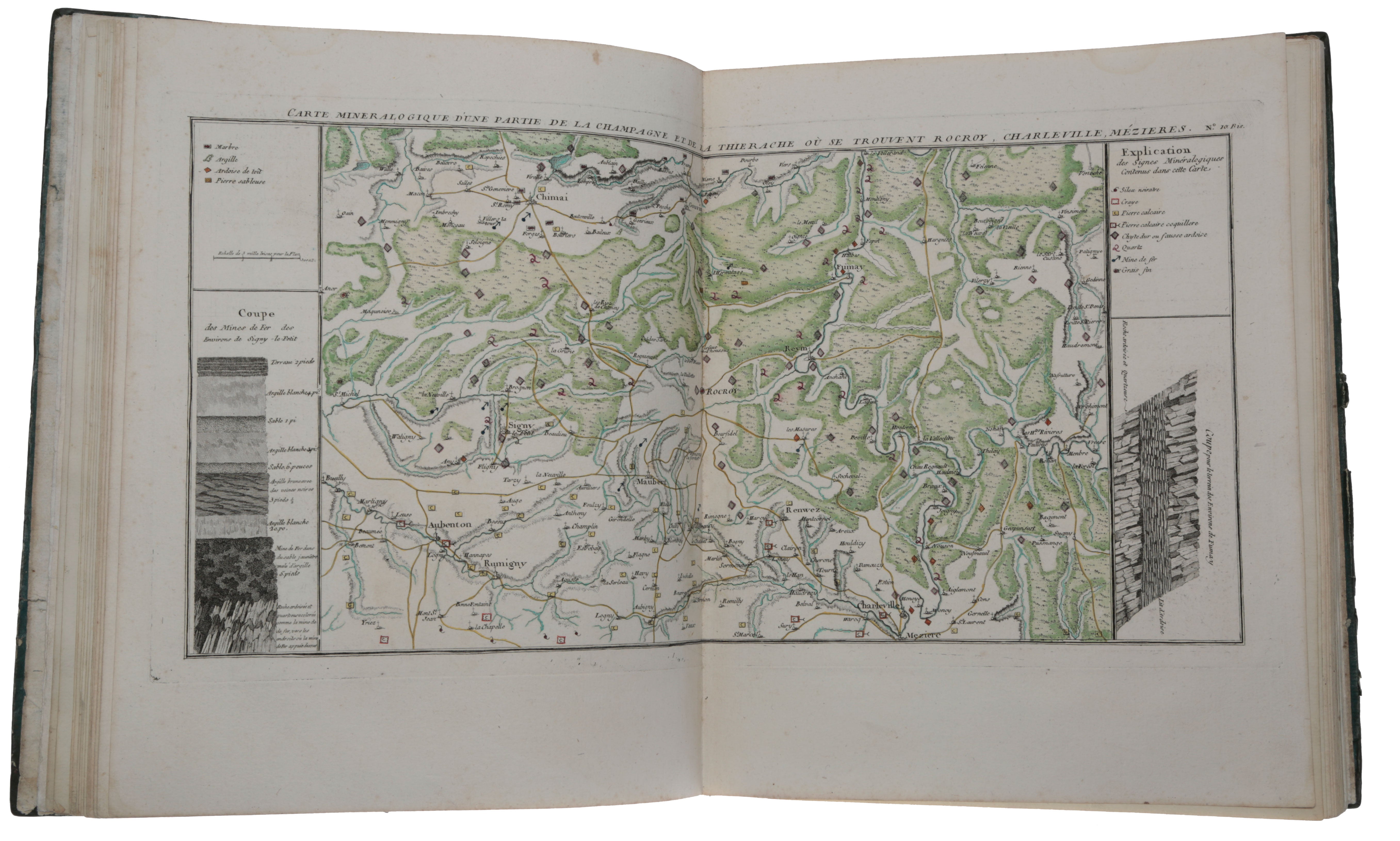
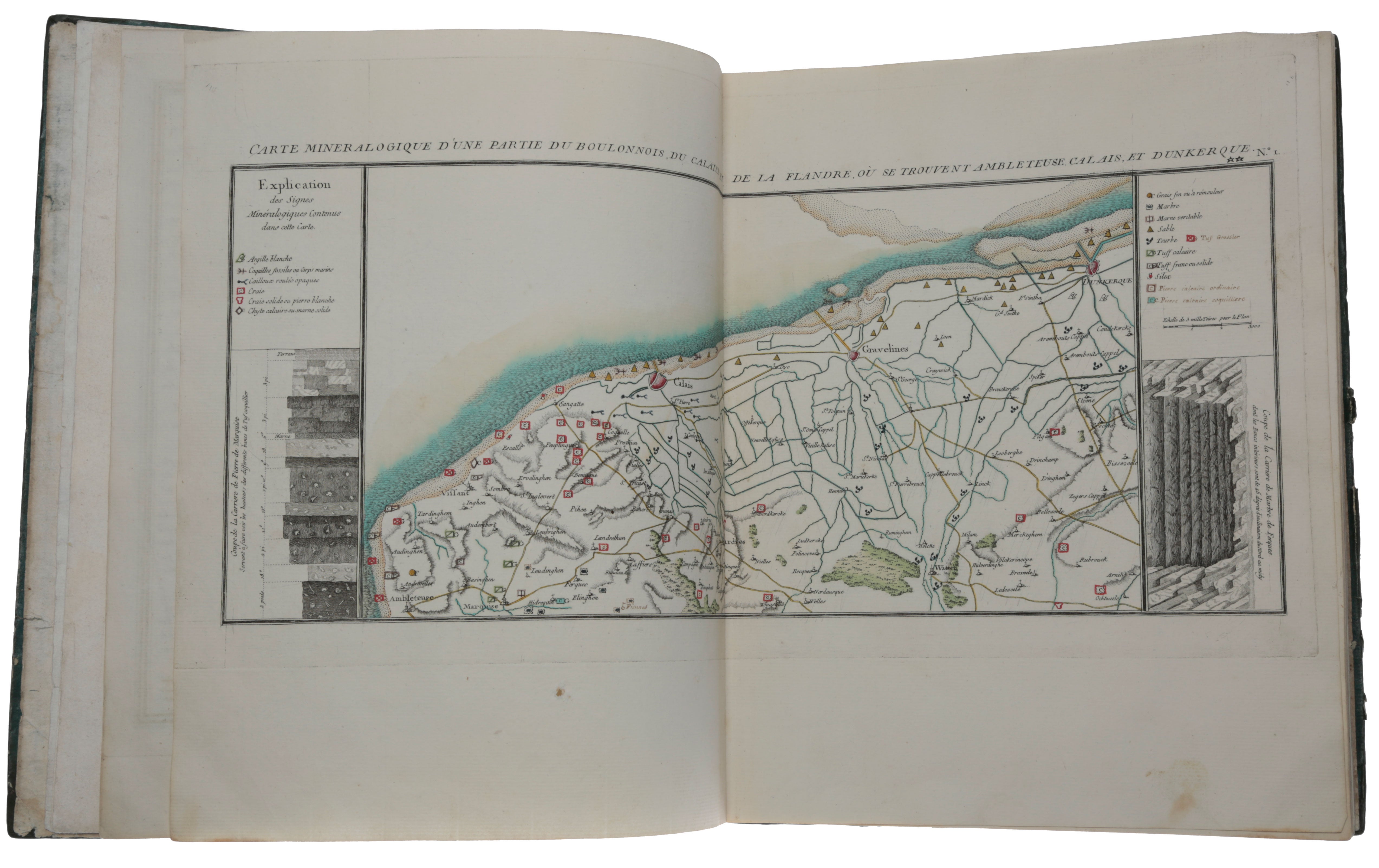
A collection of 33 hand-coloured mineralogical maps of France prepared for the first geological atlas.
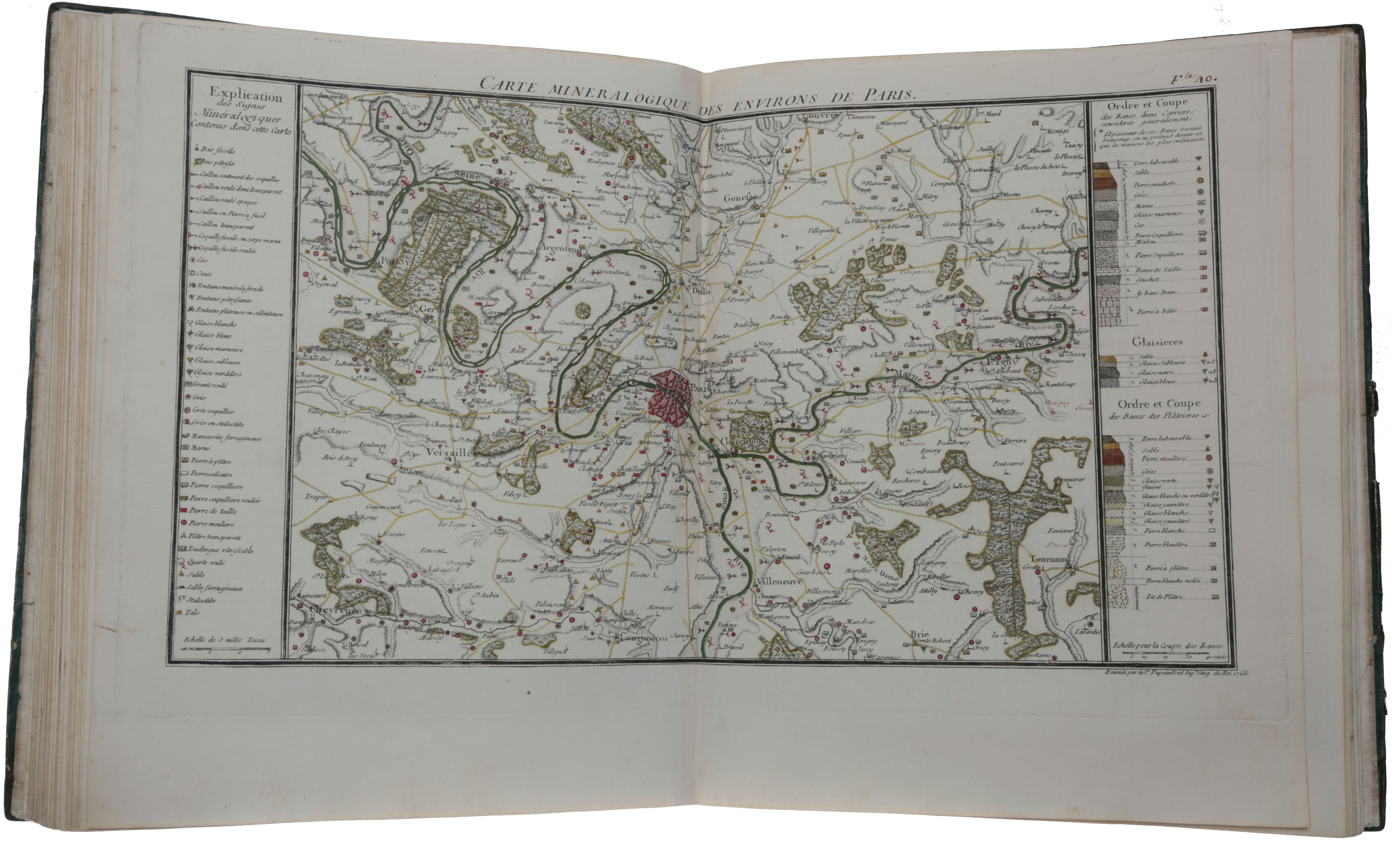
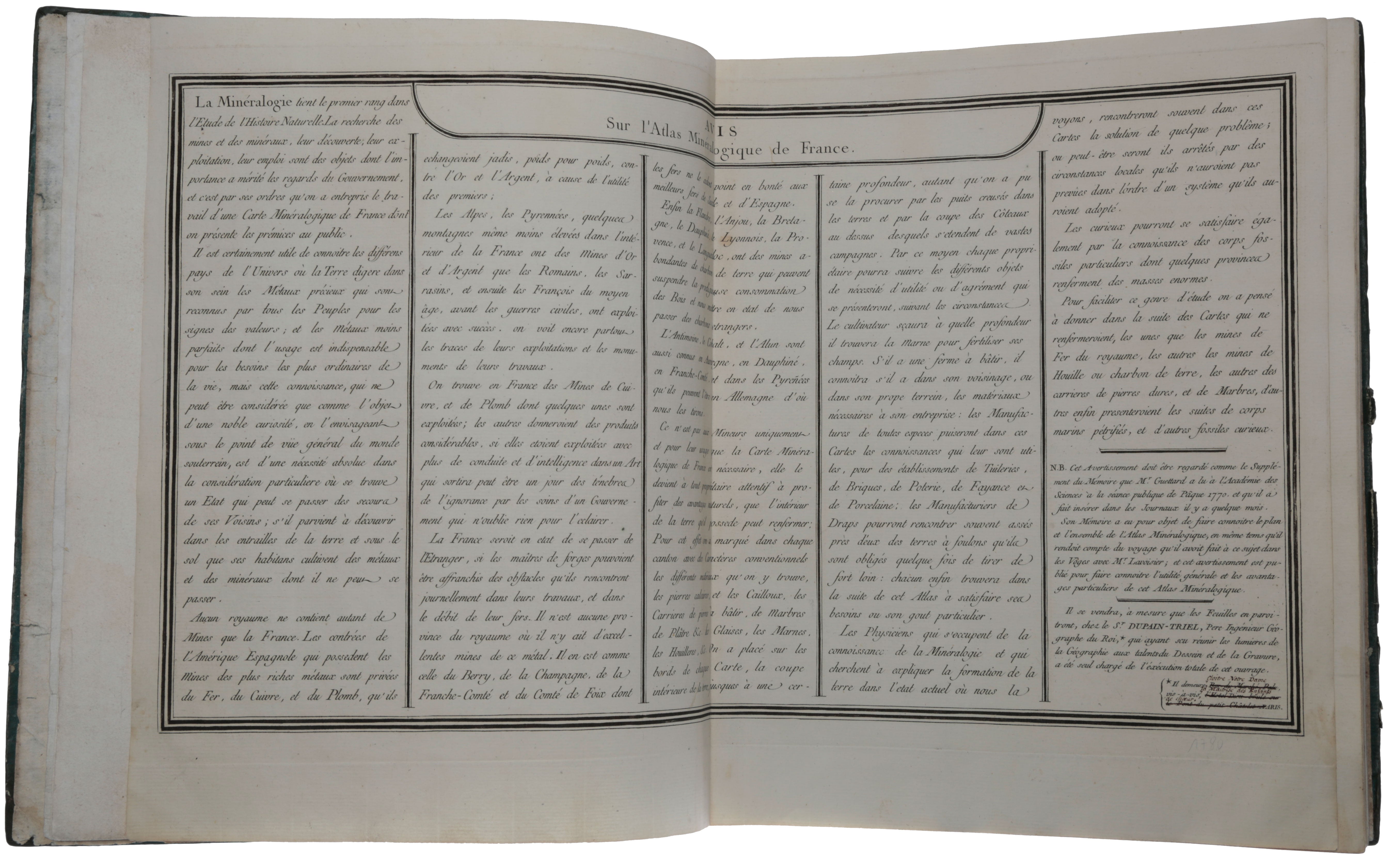
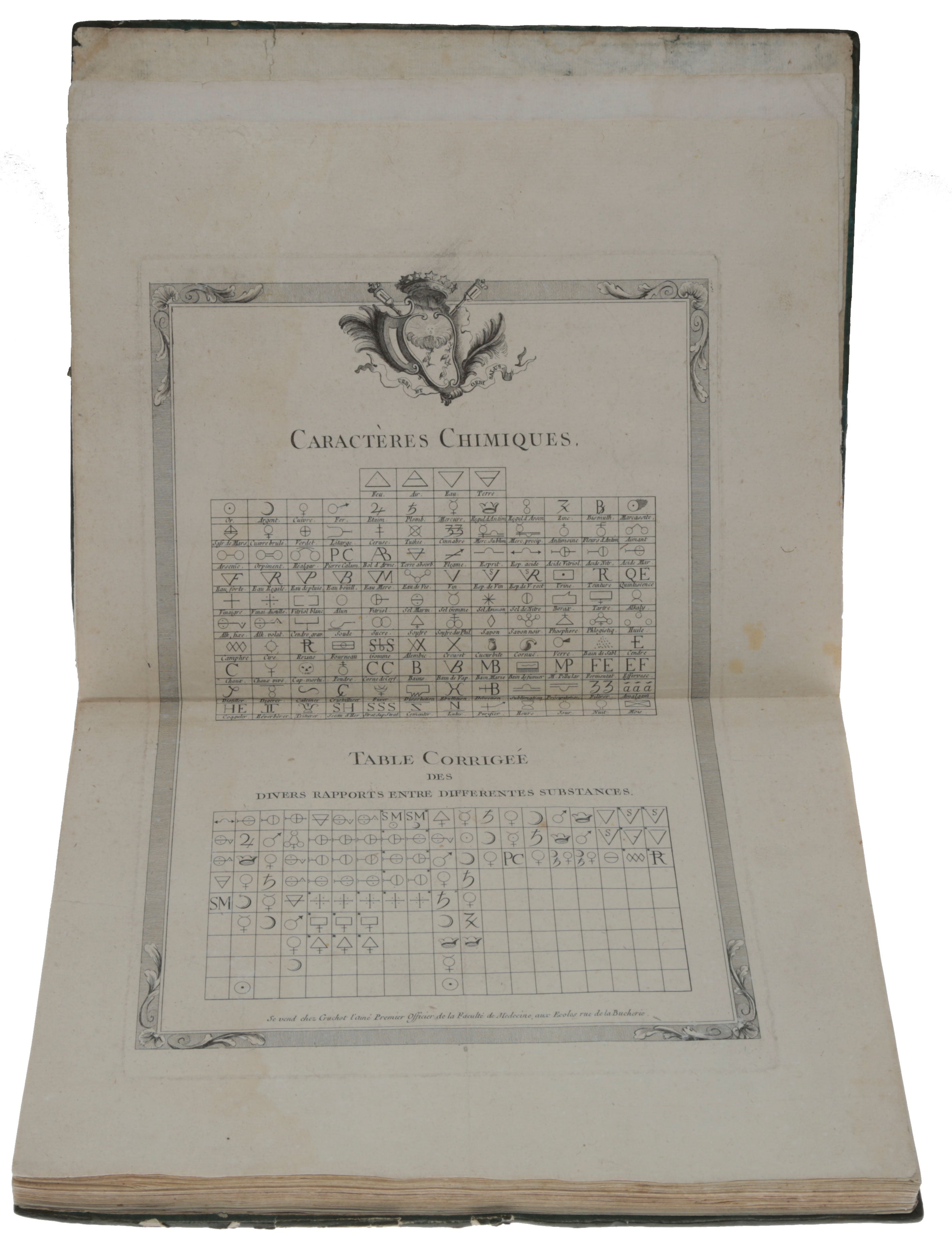
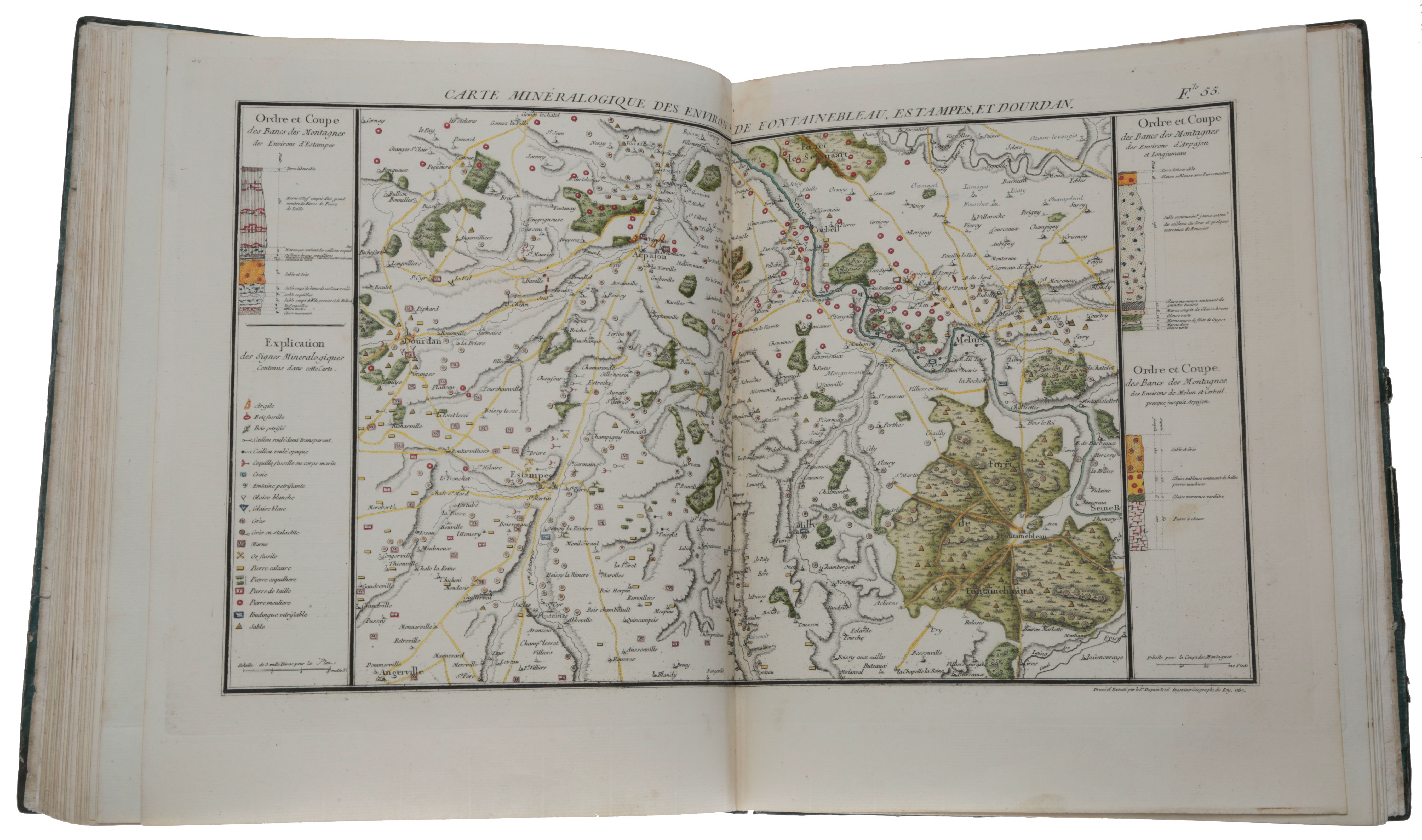
N.p. n.d., ca. 1766-1780. A unique collection of maps prepared for the first geological atlas of France. “These maps, so far as I know, were the first ever constructed to express the superficial distribution of minerals and rocks. The gifted Frenchman [Guettard] who produced them is thus the father of all the national Geological Surveys which have been instituted” (Geikie, p. 115). “In 1763 the distinguished naturalist Jean Étienne Guettard, an old friend of Lavoisier’s father, was advising Lavoisier and may have taken the latter under his wing as early as 1761. Guettard criticized the traditional approach to natural history and advocated a science of mineralogy supported by chemistry, topography, and physics. Since 1746 Guettard had been collecting material for a mineralogical map of France, but the task proved to be too great for a single naturalist. After Lavoisier’s apprenticeship, Guettard, in 1763, decided to take the young scientist along as his assistant during his geological and mineralogical excursions outside Paris. Guettard’s interdisciplinary approach to mineralogical research became evident in the writings of the young Lavoisier at a very early stage” (DSB). “In 1766 Henri Bertin, Minister and Secretary of State in charge of mining, commissioned a geological survey of France from mineralogist Jean-Étienne Guettard, one of the first geological cartographers, and Guettard’s protégé, Antoine-Laurent Lavoisier. Guettard and Lavoisier had begun collecting field notes for the project as early as 1763 and in 1767 they embarked on their famous geological tour of Alsace, Lorraine and Franche-Comte … When Lavoisier returned to Paris, he assumed most of the responsibility for supervising the production of the geological maps, which were engraved by the Sieur de Dupain-Triel, Royal Geographical Engineer. By 1770 he and Guettard had overseen the completion of 16 plates and by 1777 they had a partially completed an almost equal number … The atlas was to have contained 230 maps in all, but this number was never reached, as political and financial difficulties intervened. In 1777, to the displeasure of both Lavoisier and Guettard, Antoine Monnet, France’s first Inspector-general of mines, was appointed to direct the geological survey. In 1780 thirty-one maps were published under the joint authorship of Guettard and Monnet as Atlas et description minéralogique de la France … Monnet issued a second edition of the Atlas some time after 1794, under the title Collection complète de toutes les parties de l’Atlasminéralogique de la France” (Norman). The maps were available to purchase individually, as well as in the Atlas and Collection. The present collection of maps comprises 23 of the 31 maps that appeared in the Atlas; the remaining 10 maps were published in the Collection. According to Duveen & Klickstein, 18 of the maps are credited to Lavoisier, of which all but one are in the present collection. “Lavoisier’s early work was markedly influenced by Jean Étienne Guettard who, as a friend and mentor, exerted his guidance with intention and purpose. Guettard had a wide knowledge of natural history, much of his work being done in mineralogy and geology. Many of his doctrines now appear to have been correct but to his contemporaries they seem strange. He thought that some mountains were extinct volcanoes and that fossils were geological formations originating from plants and animals, etc. He also was the first to make geological maps or, as he termed them, mineralogical maps. Maps of Egypt, Palestine, Canada and Louisiana were prepared by him. The preparation of a mineralogical atlas of France soon became his chief interest and a project to which he was to devote the rest of his life. “It was under the guidance of Guettard that Lavoisier, in 1763, began to make studies in mineralogy and field geology. He undertook investigations of mountain heights, of strata and of gypsum. The work on gypsum resulted in his first printed publication. Lavoisier soon became a valuable assistant, if not a colleague, in the accumulation of data for the atlas. Beginning in 1763 Lavoisier collected field notes that now occupy many pages in the Oeuvres. In 1767, he accompanied Guettard on a tour through the east of France, the Vosges, Alsace, Lorraine, and parts of Switzerland. It was an exhilarating experience for Lavoisier. The young scientist ascertained the levels of various strata, collected rocks and minerals, examined mineral waters, and assisted Guettard in innumerable ways … “After the tour, Lavoisier immediately turned to the task of correlating and arranging the mass of information that had been collected on the trip … With Guettard he was associated in the preparation of the geological maps; most of the detail work fell to Lavoisier, and by 1770 he had supervised the engraving of 16 plates for the series which, it was expected, would run to 230 maps for the whole of France. Guettard, when he announced the completion of the first 16 plates to the Académie, spoke of Lavoisier’s cooperation in laudatory terms … “By 1772 it was evident that the funds which had been voted for the project would be inadequate, and a halt was therefore called to the proceedings. Presently the retirement of Guettard and political intrigues intervened and the project was handed over to Monnet, inspector general of mines, for completion. Monnet added 16 more plates and a long text, publishing the whole as the first part of the atlas. It was issued under the joint authorship of Guettard and Monnet. All of Lavoisier’s contributions were ignored, except for the first sixteen plates; the wealth of information that had been gathered was used without his permission. The feature of showing levels of geological strata was due to Lavoisier’s initiative, a point Monnet chose to withhold. The former, angered by this treatment, protested bitterly, but to no avail. Monnet had become his obstinate enemy, continuing to attack the new chemistry even after Lavoisier’s execution … “According to an anonymous review of the first sixteen plates, which was published in Rozier’s Observations sur la Physique, Vol. 9 (1777), 395-397, the maps already completed at that time were separately available to the public at the office of Dupain-Triel, who had engraved them, in both black and white (1 livre 10 sols) and colored (2 livres) copies. It is also stated in this source that fourteen further plates were already in an advanced state of production … “The following year (May, 1778), the Observations sur la Physique (Vol. 11, 459-462) brought a ‘Nouvel Avertissement sur la Carte Minéralogique de la France; par M. Monnet, Inspecteur-Général des Mines,’ which again gives Guettard credit for the original conception and Lavoisier for his collaboration in the preparatory work, and states that they had both completed the previous year (1777) the maps no. 25, 26, 27, 28, 40, 41, 42, 55, 56, 57, 60, 61, 75, 76, 89 and 90, and that Dupain-Triel had completed eight more maps in the meantime. Two years later another short notice in the Observations sur la Physique (Vol. 15 (1780), 423) announced that a third lot of eight plates for the atlas is now available, the numbers 17, 16, 15, 8, 9, 18, 10 bis, and 10, and that these eight plates, like the preceding 25 [i.e., 24], were to be obtained at the establishment of Dupain-Triel … “Even if the affair of the Atlas turned out to be unfortunate, Lavoisier had gained a great deal from his geological travels with Guettard. His published papers on various aspects of the tour and his many manuscripts which, as has been stated, were only printed after his death, all bear testimony to the development of his scientific interests. Nor should the fact be forgotten that his collaboration with Guettard on the tour added to his reputation among the scientists of Paris. Later when Lavoisier became well-established, he exerted his influence in furthering the mineralogical atlas. He issued a circular and questionnaire on rocks and mineral deposits and also approached government officials for funds to continue the publication of the atlas. Deliberations about the work, in which Lavoisier had obviously the initiative, occur repeatedly in the proceedings of the Administration de l’Agriculture” (Duveen & Klickstein, pp. 236-240). The plates in the present collection are nos. 1, 1 bis, 2, 2 bis, 3, 4, 5, 7, 8, 9, 10, 10 bis, 14, 15, 16, 17, 18, 25, 26, 27, 28, 40, 41, 42, 55, 56, 57, 61, 75, 76, 89 and 90. Those published in the Atlas are nos. 1, 1 bis, 2, 2 bis, 3, 4, 5, 7, 8, 9, 10, 10 bis, 14, 15, 15, 16, 17, 18, 19, 20, 25, 26, 27, 28, 29, 30, 31, 41, 42, 43 and 45. The plates credited to Lavoisier are nos. 1, 2, 3, 4, 5, 7, 8, 9, 14, 16, 17, 25, 26, 27, 28, 41, 42, and 43. The present collection begins with an engraving with two tables, ‘Caractères Chimiques’ and ‘Table Corrigée des divers Rapports entre différentes Substances’. This appears to be a modified version of the tables in the ‘Mémoire sur de nouveaux Caractères à employer en Chimie’ by Hassenfratz and Adet, which appeared in the Méthode de Nomenclature Chimique (1787), by Morveau, Lavoisier, Berthollet and de Fourcroy. This is followed on a separate sheet by ‘Avis sur l’Atlas minéralogique de France,’ which is present in the Atlas; this has manuscript corrections. The collection concludes with an index engraving of a map of France, with the regions numbered; those which are covered by the maps in the collection are coloured (this is also present in the Atlas, but with slightly different colouring as the plates in this collection are not quite the same as those in the Atlas). Duveen & Klickstein, A Bibliography of the Works of Antoine Laurent Lavoisier, 1954. Geikie, The Founders of Geology, 1897 (see the entire chapter devoted to Guettard and his geological achievements). Norman 1287 (a preliminary issue of the first 16 maps to be produced, without the numbering which was added later for their appearance in the Atlas). Rappaport, ‘Lavoisier’s geologic activities, 1763-1792,’ Isis 58 (1967), pp. 375-384. Schuh, Mineralogy & Crystallography: A Biobibliography, 1469 to 1920, 2025 (for the Atlas).
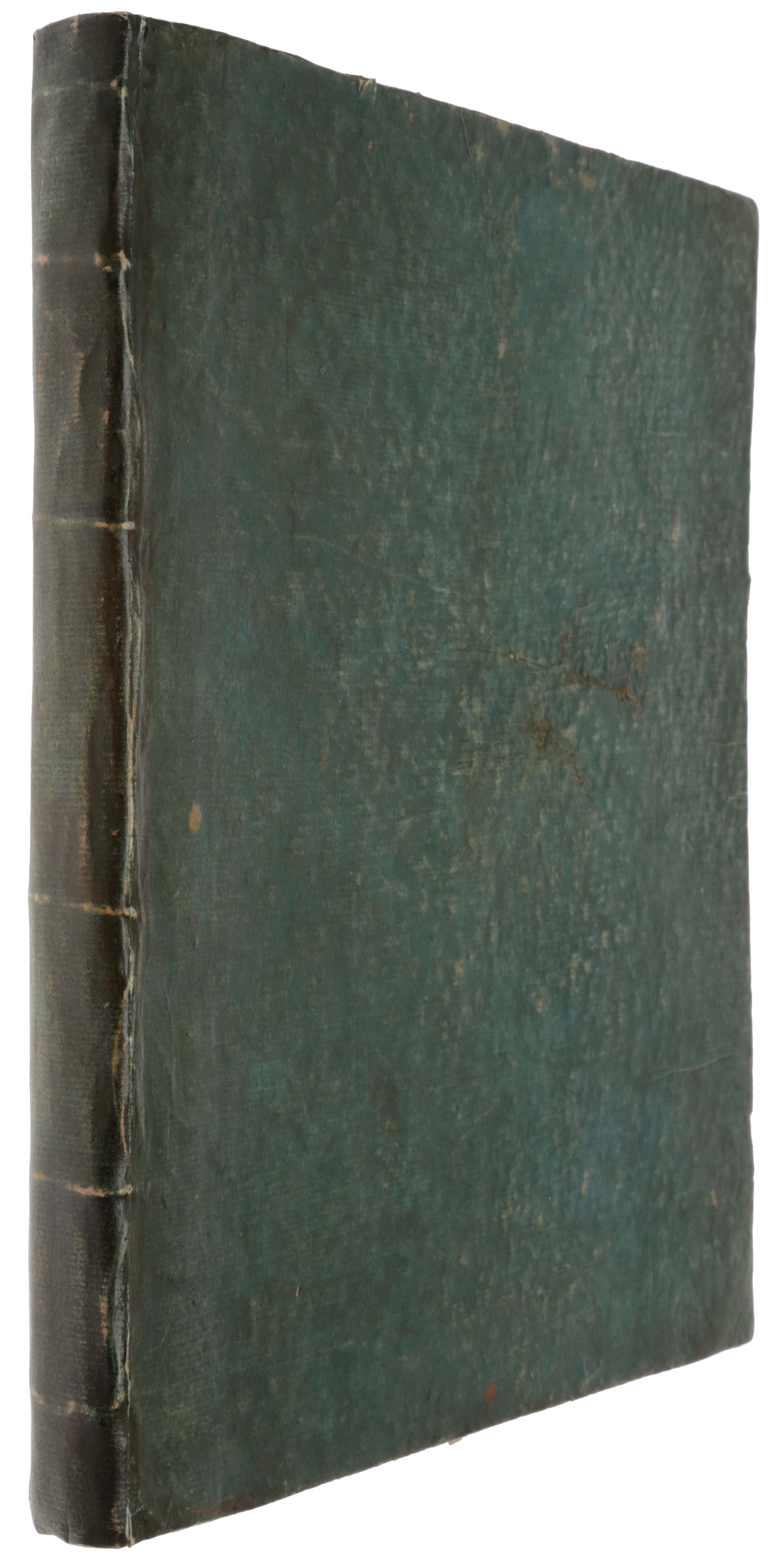
Folio (310 x 257 mm), ff. 35, leaves printed on recto only, including 32 geological maps and an index map, all of which have contemporary colouring. Contemporary gree paste-paper boards. Very fine.
Item #5379
Price: $55,000.00
